Thursday, January 24, 2008

Casa Piedra

Casa Piedra is a beautiful beach house that can best be described as Robin & Caruso meet the modern world. It is built entirely from native stones and rough hewn beams with a palapa roof. There is a stone patio that surrounds the house where we have been enjoying breakfasts looking over the Sea of Cortez and sunning in the wind shadow of the house in the afternoon.

The house sits on a beautiful white sand beach which it shares with probably 15 other houses of which only half are currently occupied. It is a busy day on the beach if we see two people walking.


We spent our first three days at the house relaxing, walking on the beach, falling asleep to the sound of the surf and waking to the sunrise over the Sea of Cortez (yes, we really did watch the sunrise...right before we went back to sleep!) While enjoying our breakfast on the 2nd day we noticed some large fish jumping about 500 yards off shore. We grabbed the binoculars and discovered that it was not fish at all but Manta Rays. We sat transfixed watching the spectacle of the leaping rays for several hours until they moved on. Unfortunately they were too far off shore to get a clear picture and we're still hoping they will return.

On the 4th day we were finally ready to face the prospect of getting back into the car to explore the area around the house. First we headed farther south about 5 miles on the dirt road to Cabo Pulmo which is a small village on the beach which caters to people who come to dive or fish on the reef. The reef at Cabo Pulmo is the only living reef in the Sea of Cortez and one of the few coral reefs on the west coast of the Americas. It's a marine preserve and closed to commercial fishing so it is a haven for the divers and sports fishermen willing to come this far off the beaten path. The village consists of several dirt streets and a very small collection of ecclectic shops and restaurants. We continued another 5-6 miles to Los Frailes where we gathered the courage to test our less-than-impressive Spanish and successfully purchased a freshly caught 2 pound Red Snapper for 45 pesos ($4.25) from the fisherman on the beach. He was also selling Manta Ray, but we weren't feeling quite that adventurous. In the afternoon we went North into La Ribera and purchased "supplies" (read: BEER) at one of the small groceries in town.

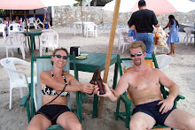
On the 5th day Randy and Linda joined us in our borrowed paradise. We spent a week playing beach volleyball, hiking, eating (excessively), drinking (excessively), relaxing, watching movies and playing an addictive game called Sequence!! Randy had wisely packed his kite board (winter is windy season in Mexico) and took it out twice and "wowed" us with his kite boarding expertise. Feel free to ask Randy for the details on the Baywatch rescue!


On Thursday the wind was blowing hard and the clouds had moved in so we decided it was a perfect day to explore inland where it would be warmer. We had been told about a place called Canon de Zorro (Fox Canyon) that had a beautiful waterfall and clear pools for swimming. To get to there we passed through the small picturesque town of Santiago then followed a dirt road another 6 miles to the canyon entrance. We hiked the 1/2 mile trail to the waterfall and then had to scramble down a steep rock wall using ropes to reach the base of the waterfall. This proved to be a bit of a challenge because our Canadian friend had a cooler full of beer and our dog has no hands to hold a rope. It was all worth it. The waterfall is amazing and the pool at the bottom is crystal clear and we enjoyed cooling our feet in the cold water until we noticed the snake swimming in the pool. So, we retreated to the shore to cool of with una cerveza fria. This is about a 2 hour drive from Cabo San Lucas and well worth the trip if you are in the area.

Sadly, we had to drive the Nealy/Polajzar team back to the airport Sunday and send them back to the snowy Pacific Northwest. Hopefully their tans will help see them through it!

We cooked, relaxed, read and organized today and Cayenne said goodbye to her new doggie friends so we could head back out on the road tomorrow, round the tip of the Baja Peninsula and start a SLOW journey back north!


Friday, January 18, 2008

The Road South

After 3 days of relaxing at Guadalupe Canyon Hot Spring, we could have easily stayed a week here, we were forced to move on if we were to make it to the house in Cabo Pulmo by the 15th. We loaded the Jeep and slowly maneuvered the boulder strewn road out of the canyon. On the way out we opted for the dry lake bed route to avoid the 27 miles of washboard that we had driven in on. It hadn't rained since before we arrived and the workers at the camp assured us that the route should be passable. In truth it was the not so dry, dry lake bed route. All we can say is thank God for 4-wheel drive and off road tires. The most interesting thing of note on this route is that it is so frequently traveled that there are actually road signs in the middle of the dry lake.

Back on the highway we passed through the outskirts of Mexicali and made it to San Felipe in a few hours. Not much to say about most of this section of highway except flat, straight and flat, straight and flat. The last 20 miles or so winds through some low hills and then you finally get the first glimpse of the Sea of Cortez. That night we camped just north of town at Pete's Camp. There is nice area to park right on the beach with palapas and we had to share the beach only with a couple from Alberta (Leif & Susan Erickson) and an old school bus converted to an RV. Leif and Susan, thank you for sharing your campfire, stories and the great little drink table.

The next day's challenge was how to get from San Felipe which is on the East coast of Baja to Highway 1 which at this point is running down the West coast. We had already ruled out the route running south down the east coast through Puertecitos which we heard has a particularly nasty 75 mile stretch of severe washboard. The most sensible route would be to head NW 120 miles up to Ensenada and then turn back south on Highway 1. We of course chose option 3. This was to take a secondary road off Highway 3 at Lazaro Cardenas that heads southwest through an area knows as Valle La Trinidad and a small community called San Isidro. On the map this is a fairly straight 30 miles which should save us the 120 miles to Ensenada plus another 60 miles back south on Highway 1.

Not finding any highway signs in Lazaro Cardenas we stopped at the only Pemex (gas station) in town and asked directions. Wow, I really wish we had taken some more Spanish lessons this year. The attendant patiently explained the route and we were on our way. After leaving the small town, still following the attendant's directions, we made the right off of the hard packed dirt road we were on to another track running between farm fields and were faced with several large mud holes that again had us in 4-wheel drive. As this road wasn't looking promising we turned around in the driveway of a small farm house to the amused waves of the children in the yard. At this point we had the GPS on and of course the road we were following wasn't in its map file so it only gave us a general sense of where we were by comparing it to the road atlas. We figured we must have gotten the directions wrong (boy those Spanish lessons sure would have been a good idea.) We went back through the mud to the hard packed road and flagged down the first pickup and asked directions to San Isidro. The men in the first truck didn't appear to know the way to San Insidro and neither did the driver of the 2nd truck we stopped, but he did know the way when we said were trying to get to La Paz. He again directed down the road with the large mud holes. We turned back again passing the children in the front on the small farm and we eventually intersected the road we had been looking for and turned west.

This road was much better but in the states would have only rated a class c fire road. It was a one lane washboard track running through the desert scrub, but we were able to manage 20 mph so we figured in 1.5 hours we would be back on the highway and we hoped the road would improve once we reached San Isidro. The GPS showed we were heading in a generally westward direction so we pushed on passing through beautiful green desert foothills which were of course a precursor to the mountains we would also be passing through. As the road climbed it deteriorated and soon were were grinding along at 5-10 mph skirting washouts, boulders and sheer drops. We never did find the town of San Isidro. All we could figure was that it was a collection of a few small shacks and a herd of goats that we passed through before entering the mountains. It really wasn't even enough to consider a farm. After 2.5 hours and passing one car and a man on a horse we reached Highway 1.

We stopped for supplies in San Quintin and while Dana was in shopping I met a Gringo in the parking lot named Russ who lives in La Ribera, the town just north of the house we are renting. He of course knew the house, its owners and told us our biggest problem was we weren't going to want to leave. His wife Kim works at the Coldwell Banker office in the area and he told us to stop and see her if we need advice on finding anything in town.

One of the unique things about driving in Mexico is that when you meet others from North of the border (USA or Canada) whether on the street, in a parking lot, or gas station they always stop and strike up a conversation. They are always willing to share advice or help with whatever you need. This is quite a change from the States where we rarely talk with strangers and this sort of behavior would probably be perceived as just plain weird. I am not sure if has to do with the type of people who are willing to undertake a road trip through Mexico or just the fact that we are all sharing in the same grand adventure.


We stopped for the night in San Quintin as it was getting dark and camped at an RV park that was little more than a gravel parking lot. The only up side is there was a propane dealer next to the park and in the morning we were able to fill our tank. The attendant was a cheerful older Mexican man that had lived for several years in Yakima, small world.

From San Quitin south to Guerrero Negro is a stretch of highway know as the gas gap. It is 200 miles of road with no gas stations. There are several spots where people are selling gas from the back of pickup trucks, at I am sure greatly inflated prices, to those that are unprepared. This is a beautiful stretch of road that passes through miles of cactus forests and fields of boulders the size of houses. We camped for the night in Guerrero Negro at the Malarrimo RV park. This is a small RV park behind a restaurant. We had a peaceful night and were up early the next morning heading for Bahia Concepcion on the Sea of Cortez where we hoped we would be camping on the beach again.


We Reached Bahia Conception about 2pm and found a spot on a beach between Richard and Marny, a spunky retired couple in a 5th wheel trailer from Canada, and Gailene a massage therapist from New Zealand who was sleeping in a tent and trying to earn enough money by doing massages to get the engine in her truck rebuilt. We also met Gary, a quirky artist from the Bay area, who was camping in an older minivan and Dustin, the outgoing son of a father and son team leading a caravan of RVs, who seemed glad to meet a couple of people his own age. The bay was beautiful and we were camped only a few yards from the shore. There was a stiff wind blowing which made setting up the tent a group effort, thanks Dustin. We had a pleasant evening visiting with everyone and went to bed early because the next day we had a long day of driving to make La Paz. Unfortunately at about 2:30am the wind came back with a vengeance and we had to get up and pack the tent up for fear it might end up in the middle of the bay. Then we retreated to the safety of the Pod for the rest of the night.

The next morning we were up at 7 and on the road by 8, having already packed the tent, for the anticipated 8 hour drive to La Paz. This section of road is one that gives you the sense that the Baja is huge and very sparsely populated. After leaving a small range of mountains the road heads down a gentle slope and is arrow straight until it disappears over the horizon, with nothing visible but desert scrub brush and cactus. Along this stretch there are a few small roadside restaurant/rest stops and little else. We were passed by four guys on motorcycles who we later passed at one of these stops. They were all waving at us, which with the pod is not uncommon. The weird part was they passed us again just as we reached La Paz and one of them shouted something to us as they passed. Because of his helmet his voice was muffled but we both swore he said "Hi John & Dana." We puzzled at who this might be all the way to the campground, presumably someone we spoke with at one of the stops along the way.

LaPaz is one of the largest cities on the Baja and the last large one we would pass through before reaching the house in Cabo Pulmo so we stocked up on supplies. We camped at the Casa Blanca RV park. Nothing special but it was well run and clean. We met Dave & Beverly who were driving a Sportsmobile which is what we hope to be driving our adventures in the near future. That's right you heard it here first...we will be buying a real RV, sort of. It is really a conversion van with a beefy 4x4 suspension. Thanks guys for the tour of your van and all the great information. Beverly we hope the winds are blowing for you in La Ventana and that you guys have a great trip.

We also met Uto and Kimberly a German couple who were traveling in an RV fit for an Ogre, Jerome we could so see you stepping out of this.
They had it shipped over from Germany and are on an 8 month trip that will take them from Alaska to Central America. Good luck guys!


From La Paz we made a short 2 hour drive to the house at Cabo Pulmo. We will post more on the house later.


P.S. Dale, Karla and Laurie, Cayenne would like to thank you for her new toy.

Friday, January 11, 2008

Finding the sun...

We relaxed, regrouped and restocked for a couple days before heading across the border. Did we mention it still hadn't stopped raining and the wind was even knocking down trees in Chula Vista? The morning of January 7th we packed our soggy tent and headed farther south, and no Eric, we don't want to hear about the sun in Seattle.

We'd been told the Tecate border crossing was rarely busy, but we weren't expecting to be the only car among a handful of semi trucks. We had trouble figuring out which way to go until another car showed up, honked politely and gave us the courage to drive right past the 18-wheelers. We got the "red light" this time, largely because the six border patrol officers were extremely bored. Fortunately we received lots of smiles, a cursory search and much need advice on obtaining our tourist cards. Did we mention it still hadn't stopped raining?
Next came bored immigration officers, more smiles and directions and then we were off on Highway 2 in Mexico. Destination for the day; Arturo's hotsprings in Guadalupe Canyon. And guess what, about 50 more miles of driving and we finally found the sun!

We opted for the new toll road through the Sierra de Juarez Mountains. This seemed like an exceptionally good decision after we noted that the tolls were obviously helping to pay for many brand new, extremely sturdy looking guard rails. We learned how important they were when we reached the first view point. The wrecked cars literally lined the canyon walls like discarded beer cans rusting away on the bolder strewn cliffs. After that freakish sight we firmly claimed the "granny lane" as ours and safely made it through the mountains to the next fork in our road.

Turning south off the highway we left the pavement behind for the 35 mile journey to the hotsprings.


The road into the hot springs was absolutely heinous. Was it worth it?...every single 4-wheel low, rock crawling mile. With three days to enjoy our private hot spring pool we ended the day snuggled up by the fire in our palapa, sipping some delicious wine (thanks Randy, Polajzar juice hits another country) and nibbling on scrumptious "Mom McMullin" cookies. Tomorrow's agenda: sit in hot springs, sit in sun, nap, repeat...


Saturday, January 5, 2008

The Beginning of the "non" Adventure

The morning of January 3rd had us up at 5am and racing southward an hour later in an attempt to beat a storm sytem that was closing in on the Siskiyous in southern Oregon. The National Weather Service issued a storm warning for 4pm that day and a blizzard warning for Friday. Over 4 feet of snow was expected with winds of over 50mph. Needless to say we wanted to make it over the pass before the full brunt of the storm hit. Being responsible travelers we checked the Oregon chain laws on the DOT website and found we would have to chain the Jeep (Jerome, perhaps the people you encountered on your trip back from Christmas were Oregonians) but not the trailer, because it had no brake, so we packed our chains and were off.

As we neared the pass the signs read, "chains required" so we pulled off and put on our chains, however we were turned back at the checkpoint because we did not have chains on the trailer. It appears as if the State Patrol has not read the Oregon chain law posted on the DOT website. We then had to take the chains off the Jeep and drive back to the nearest town and buy chains for the trailer. With chains in hand we headed back up the pass only to find that the chain requirement had been lifted and the pass was bare and wet. ARRGH!!

Once in California we were stopped again and had to put chains on the trailer only. We ground along on bare and wet pavement for about 20 miles before deciding to pull over and take off the chains. Welcome to California!

As we neared Sacramento, our destination for the day, the rain began to relent a little but only to be replaced by a strong headwind. The wind was so strong that even on level road we were forced to shift down to 4th gear just to maintain 50mph. We pulled into the KOA in Sacramento at about 12:30am exhausted, (thanks for the espresso beans Santa Fred!) crawled into the pod and went to sleep. 760 miles and still no sun.

We woke to the pod rocking from side to side (not us this time) and the sound of the rain slamming aginst the side driven by the howling wind. The power was out at the campsite so the hot shower we had hoped for was out of the question. Instead it was Starbucks for a cup of Joe and we were headed south like a sun seeking cruise missle. We had vowed not to stop until we reached San Diego or outran the storm. A decision we would later regret.

Pulling out of the Starbucks parking lot Dana asked, "Won't the pod tip over in the wind?" My only reply was "I don't know, but we are not staying here." To give you an idea of the severity of the storm at its height over 1 million people in Sacramento were without power. The Sacramento paper reported that the winds were sustained 50 mph with gusts up to 80 mph, and that flights were grounded at all the airports in Northern California.

Buffeted, but undeterred, we struck out across the San Joaquin Valley. About halfway we passed a semi-truck that had lost control and spun completely around before coming to rest on its side. 900 miles and still no sun. Toward the southern end of the valley the rain finally began to relent, although we were still fighting strong headwinds. Passing a sign that read next gas 35 miles and with the needle indicating 1/4 tank we decided to pull off and fuel up. At this point we were unaware of the severity of the power outages and all of the gas stations at this exit were blacked out. Normally 35 miles on a quarter tank would be no problem, but with two Yakima roof boxes, towing a trailer and fighting a 50mph headwind in 4th gear we were only averaging about 10mpg and to top it all off we hit stop and go traffic with 15 miles to go. We pulled off the exit with the needle pointed at E and were relieved to see the lights were on.

The storm still had one surprise in store before letting us cross the mountains into Southern California, where we hoped to finally be rid of it. A dust storm, luckily not the blinding zero visibility kind that cause huge multi-car pile ups, but the kind that periodically slows traffic to a crawl and fills the car with dust if you don't turn the heater off in time. Lovely!

At the very south end of the valley we stopped for fuel and the wind had died to a about 20 mph and the rains had stopped. We were looking forward to crossing the mountains and seeing the clear skies of Southern California. Mother Nature however had different plans. As we began to climb the rain started again. The kind of rain that is usually associated with biblical events. It was like driving with a fire hose pointed at the windshield. Oh yeah, and the wind was back at full force. To make matters worse, because we were pulling a trailer, we were restricted to the right two lanes with the semi-trucks. Now I know what people mean when they say "white knuckle driving." We pushed on, cresting Tejon pass and dropping into Southern California. Finally, about 7pm, we had reached L.A. 1100 miles and still no sun.

Slogging through L.A.'s flooded freeways we hit the outskirts of San Diego at about 10pm, the rain finally stopped and the roads were dry. We arrived at the campground in Chula Vista at 10:30 only to find the gates locked. Fortunately the night caretaker let us in and we were not forced to camp at the gate. He informed us that the rain was supposed to start any time so we hurriedly set up camp and as we were getting the tent on the side of the pod the rain began to fall. We fell into bed completely exhausted, but relieved that we had made it and with the knowledge that we had two days to rest before we had to move on again. 1300 miles and still no sun.